Chapters (26)
- CAPTAIN COOK'S JOURNAL.FIRST VOYAGE.
- CAPTAIN COOK'S JOURNAL DURING HIS FIRST VOYAGE ROUND THE WORLD MADE IN H.M. BARK "ENDEAVOUR" 1768-71A Literal Transcription of the Original MSS.EDITED BY CAPTAIN W.J.L. WHARTON, R.N., F.R.S.
- PREFACE.
- SKETCH OF CAPTAIN COOK'S LIFE.
- PERSONS WHO LEFT ENGLAND IN H.M.S. ENDEAVOUR, 26TH AUGUST, 1768.
- A JOURNAL OF THE PROCEEDINGS OF HIS MAJESTY'S BARK ENDEAVOUR,ON A VOYAGE ROUND THE WORLD, BY LIEUTENANT JAMES COOK,COMMANDER, COMMENCING THE 25TH OF MAY, 1768.
- CHAPTER 1. ENGLAND TO RIO JANEIRO.
- CHAPTER 2. RIO JANEIRO TO TAHITI.
- MODERN CHART OF SOUTH PACIFIC OCEAN SHOWING TRACK OF H.M.S. ENDEAVOUR, 1769 TO 1770.
- CHAPTER 3. TAHITI.
- FACSIMILE OF SATURDAY, 3RD JUNE, 1769.
- CHART OF THE ISLAND OTAHEITE, BY LIEUTENANT JAMES COOK, 1769. REPRODUCTION OF THE ORIGINAL PUBLISHED CHART.
- TAHITI: TYPES OF CANOES.
- CHAPTER 4. TAHITI TO NEW ZEALAND.
- CHAPTER 5. EXPLORATION OF NORTH ISLAND OF NEW ZEALAND.
- CHAPTER 6. EXPLORATION OF MIDDLE ISLAND OF NEW ZEALAND.
- WAR CANOE OF NEW ZEALAND.
- CHAPTER 7. PASSAGE FROM NEW ZEALAND TO NEW HOLLAND.
- CHAPTER 8. EXPLORATION OF EAST COAST OF AUSTRALIA.
- CHAPTER 9. FROM TORRES STRAIT TO BATAVIA.
- TRACK OF ENDEAVOUR FROM TORRES STRAIT TO JAVA. AUGUST AND SEPTEMBER 1770.
- FACSIMILE OF TUESDAY, 23RD OCTOBER, 1770.
- CHAPTER 10. BATAVIA TO CAPE OF GOOD HOPE.
- CHAPTER 11. CAPE OF GOOD HOPE TO ENGLAND.
- INDEX.
- CHART OF NEW ZEALAND, EXPLORED IN 1769 AND 1770, BY LIEUTENANT J. COOK, COMMANDER OF HIS MAJESTY'S BARK ENDEAVOUR, ENGRAVED BY I. BAYLY.REPRODUCTION OF THE ORIGINAL PUBLISHED CHART.
Sunday, January 1st, 1769. First and Latter part, fresh breezes and Clear weather; in the Middle, light Airs and Calm. At Noon, longitude in per 4 Sets of Observations between the sun and moon 61 degrees 8 minutes 28 seconds west. The Difference between the least and Greatest of these sets was 8 minutes, and the mean of 2 differs from the Mean of the whole but 32 seconds. The Longitude by account carried on from the last Observations exactly agree with these Observations. Saw a great number of small Whales about the Ship. Wind South to West-South-West; course South 36 degrees West; distance 39 miles; latitude 43 degrees 35 minutes South; longitude 61 degrees 8 minutes 28 seconds West.
Monday, January 2nd. The first part of this day a Genteel gale and Clear weather; middle, Squally, with Lightning and rain, and some showers of Large Hail Stones; towards Noon a Steady fresh breeze and Clear weather. At noon longitude in by 3 sets of Observations between the sun and moon 61 degrees 7 minutes 45 seconds, which is 43 seconds to the Eastward of yesterday's Observations. The Ship by the Log has made 4 minutes East. Wind Westerly; course South 2 degrees East; distance 92 miles; latitude 45 degrees 17 minutes South, longitude 61 degrees 7 minutes 45 seconds West.
Tuesday, 3rd. Fresh gales and clear weather; under Single Reef Topsails. P.M. Saw some Whales and Porpoises and small red Crawfish, some of which we Caught. At Noon saw several Birds of a light Grey Colour, like Pidgeons, but smaller; these are of the Mother Carey's kind. Longitude per Observation 61 degrees 29 minutes 45 seconds, which is 22 minutes to the westward of Yesterday, but the ship hath made 41 minutes, Consequently there is an Error of 19 minutes, which is not to be supposed to be in the Log in one Day's run; but, be it which way it will, it is not great. Wind West, Southerly; course South 11 degrees; distance 122 miles; latitude 47 degrees 17 minutes South, longitude 61 degrees 29 minutes 45 seconds West.
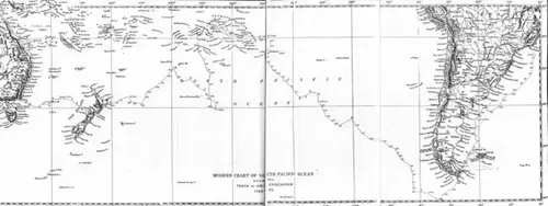
MODERN CHART OF SOUTH PACIFIC OCEAN SHOWING TRACK OF H.M.S. ENDEAVOUR, 1769 TO 1770.
Wednesday, 4th. First part, genteel breeze and Clear; latter, fresh gales, with heavy squalls of wind and rain, which brought us under our courses and main topsails close reefed. Soon after noon saw the appearance of Land to the Eastward, and being in the Latitude of Peypes Island, as it is lay'd down in some Charts, imagined it might be it.* (* Pepys' Island, placed on charts, from a report by Captain Cowley in 1683, about 230 miles north of Falkland Islands, and long imagined to exist. It was eventually recognised, after the discovery of Cowley's manuscript Journal, that Cowley had sighted the Falklands.) Bore down to be Certain, and at 1/2 past 2 p.m. discovered our Mistake, and hauld the Wind again. At 6 sounded, and had 72 fathoms black sand and mud. Variation 19 degrees 45 minutes East. Wind West-North-West to South-West by South; course South 30 degrees East; distance 76 miles; latitude 48 degrees 28 minutes South, longitude 60 degrees 51 minutes West.
[Nearing Terra del Fuego.]