Chapters (26)
- CAPTAIN COOK'S JOURNAL.FIRST VOYAGE.
- CAPTAIN COOK'S JOURNAL DURING HIS FIRST VOYAGE ROUND THE WORLD MADE IN H.M. BARK "ENDEAVOUR" 1768-71A Literal Transcription of the Original MSS.EDITED BY CAPTAIN W.J.L. WHARTON, R.N., F.R.S.
- PREFACE.
- SKETCH OF CAPTAIN COOK'S LIFE.
- PERSONS WHO LEFT ENGLAND IN H.M.S. ENDEAVOUR, 26TH AUGUST, 1768.
- A JOURNAL OF THE PROCEEDINGS OF HIS MAJESTY'S BARK ENDEAVOUR,ON A VOYAGE ROUND THE WORLD, BY LIEUTENANT JAMES COOK,COMMANDER, COMMENCING THE 25TH OF MAY, 1768.
- CHAPTER 1. ENGLAND TO RIO JANEIRO.
- CHAPTER 2. RIO JANEIRO TO TAHITI.
- MODERN CHART OF SOUTH PACIFIC OCEAN SHOWING TRACK OF H.M.S. ENDEAVOUR, 1769 TO 1770.
- CHAPTER 3. TAHITI.
- FACSIMILE OF SATURDAY, 3RD JUNE, 1769.
- CHART OF THE ISLAND OTAHEITE, BY LIEUTENANT JAMES COOK, 1769. REPRODUCTION OF THE ORIGINAL PUBLISHED CHART.
- TAHITI: TYPES OF CANOES.
- CHAPTER 4. TAHITI TO NEW ZEALAND.
- CHAPTER 5. EXPLORATION OF NORTH ISLAND OF NEW ZEALAND.
- CHAPTER 6. EXPLORATION OF MIDDLE ISLAND OF NEW ZEALAND.
- WAR CANOE OF NEW ZEALAND.
- CHAPTER 7. PASSAGE FROM NEW ZEALAND TO NEW HOLLAND.
- CHAPTER 8. EXPLORATION OF EAST COAST OF AUSTRALIA.
- CHAPTER 9. FROM TORRES STRAIT TO BATAVIA.
- TRACK OF ENDEAVOUR FROM TORRES STRAIT TO JAVA. AUGUST AND SEPTEMBER 1770.
- FACSIMILE OF TUESDAY, 23RD OCTOBER, 1770.
- CHAPTER 10. BATAVIA TO CAPE OF GOOD HOPE.
- CHAPTER 11. CAPE OF GOOD HOPE TO ENGLAND.
- INDEX.
- CHART OF NEW ZEALAND, EXPLORED IN 1769 AND 1770, BY LIEUTENANT J. COOK, COMMANDER OF HIS MAJESTY'S BARK ENDEAVOUR, ENGRAVED BY I. BAYLY.REPRODUCTION OF THE ORIGINAL PUBLISHED CHART.
"Punished Hy. Jeffs, Seaman, with a dozen lashes for ill-behaviour on shore. He had been rude to a man's wife yesterday, of which the Indian complained, and Jeffs was confined immediately the Captain had the fact plainly proved, and next morning the Captain invited the offended Parties on board, who were ignorant of his intentions. All hands being called, and the Prisoner brought aft, the Captain explained the nature of his Crime in the most lively manner, and made a very Pathetick speech to the Ship's Company during his punishment. The woman was in the greatest agonies, and strongly interceded for him. The man's name was Tuburi and his wife's name Tamide. I remember them both last Voyage. I should have mentioned Tuburi being sorry to see Jeffs punished."
It is evident, from what Cook himself tells us (above), and from what is now well known of the laxity of Tahitian morals, that this punishment would seem excessive to the natives, and especially to the women, who were accustomed themselves to bear whatever blame was bestowed.
Note. For full description of original Tahitian manners and customs, see "Polynesian Researches," by W. Ellis (London, H.G. Bohn, 1853); "Iles Taiti," par MM. Vincendon-Dumoulin et Chas. Desgraz (Paris, 1844).
CHAPTER 4. TAHITI TO NEW ZEALAND.
REMARKABLE OCCURRENCES AT SEA.
[July 1769.]
FRIDAY, July 14th. Gentle breezes at North-East and Clear weather. I have before made mention of our departure from Royal Bay on the preceeding forenoon, and likewise that I had determined to run down to Huaheine and Ulietea* (* Raiatea.) before we stood to the Southward; but having discovered, from the Hills of George's Island, an Island laying to the Northward, we first stood that way to take a nearer View of it. This Island is called Tethuroa.* (* Tetiaroa.) It lies North 1/2 West, distant 8 Leagues from Point Venus, and is a small, low, uninhabited Island, frequented by the people of George's Island for fish, with which it is said to abound. At 6 A.M. the Westermost part of York Island bore South-East 1/2 South and the body of George's Island East 1/2 South. Punished the 2 Marines who attempted to desert from us at George's Island with 2 Dozen lashes each, and then released them from Confinement. At Noon the body of York Island* (* Eimeo, or Murea.) bore East by South 1/2 South, Royal Bay South 70 degrees 45 minutes East, distant 61 Miles; and an Island which we took to be Saunder's Island, discovered by Captain Wallace (called by the Natives Topoamanan),* (* Tubuai Manu.) bore South-South-West Latitude observed, 17 degrees 9 minutes South. Saw land bearing North-West 1/2 West, which Tupia calls the Island of Huaheine.
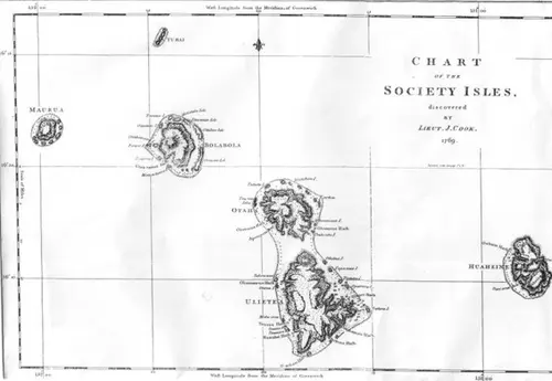
CHART OF THE SOCIETY ISLES, DISCOVERED BY LIEUTENANT JAMES COOK, 1769.
REPRODUCTION OF THE ORIGINAL PUBLISHED CHART.
Saturday, 15th. Light airs and Variable between the North and West-South-West. Clear weather. At 6 p.m. York Island bore South-East, and Huaheine West-North-West, and at 7 a.m. it bore West. Latitude observed at Noon 16 degrees 50 minutes South. Royal Bay South 37 degrees 30 minutes East, distant 22 Leagues.
[At Huaheine.]