Chapters (26)
- CAPTAIN COOK'S JOURNAL.FIRST VOYAGE.
- CAPTAIN COOK'S JOURNAL DURING HIS FIRST VOYAGE ROUND THE WORLD MADE IN H.M. BARK "ENDEAVOUR" 1768-71A Literal Transcription of the Original MSS.EDITED BY CAPTAIN W.J.L. WHARTON, R.N., F.R.S.
- PREFACE.
- SKETCH OF CAPTAIN COOK'S LIFE.
- PERSONS WHO LEFT ENGLAND IN H.M.S. ENDEAVOUR, 26TH AUGUST, 1768.
- A JOURNAL OF THE PROCEEDINGS OF HIS MAJESTY'S BARK ENDEAVOUR,ON A VOYAGE ROUND THE WORLD, BY LIEUTENANT JAMES COOK,COMMANDER, COMMENCING THE 25TH OF MAY, 1768.
- CHAPTER 1. ENGLAND TO RIO JANEIRO.
- CHAPTER 2. RIO JANEIRO TO TAHITI.
- MODERN CHART OF SOUTH PACIFIC OCEAN SHOWING TRACK OF H.M.S. ENDEAVOUR, 1769 TO 1770.
- CHAPTER 3. TAHITI.
- FACSIMILE OF SATURDAY, 3RD JUNE, 1769.
- CHART OF THE ISLAND OTAHEITE, BY LIEUTENANT JAMES COOK, 1769. REPRODUCTION OF THE ORIGINAL PUBLISHED CHART.
- TAHITI: TYPES OF CANOES.
- CHAPTER 4. TAHITI TO NEW ZEALAND.
- CHAPTER 5. EXPLORATION OF NORTH ISLAND OF NEW ZEALAND.
- CHAPTER 6. EXPLORATION OF MIDDLE ISLAND OF NEW ZEALAND.
- WAR CANOE OF NEW ZEALAND.
- CHAPTER 7. PASSAGE FROM NEW ZEALAND TO NEW HOLLAND.
- CHAPTER 8. EXPLORATION OF EAST COAST OF AUSTRALIA.
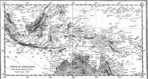
- CHAPTER 9. FROM TORRES STRAIT TO BATAVIA.
- TRACK OF ENDEAVOUR FROM TORRES STRAIT TO JAVA. AUGUST AND SEPTEMBER 1770.
- FACSIMILE OF TUESDAY, 23RD OCTOBER, 1770.
- CHAPTER 10. BATAVIA TO CAPE OF GOOD HOPE.
- CHAPTER 11. CAPE OF GOOD HOPE TO ENGLAND.
- INDEX.
- CHART OF NEW ZEALAND, EXPLORED IN 1769 AND 1770, BY LIEUTENANT J. COOK, COMMANDER OF HIS MAJESTY'S BARK ENDEAVOUR, ENGRAVED BY I. BAYLY.REPRODUCTION OF THE ORIGINAL PUBLISHED CHART.
Saturday, 25th. Winds at North-East and East-North-East, a gentle breeze. Being resolv'd not to leave the Anchor behind while there remain'd the least probability of getting of it, after dinner I sent the Boats again to sweep for it first with a small line, which succeeded, and now we know'd where it lay we found it no very hard matter to sweep it with a Hawser. This done, we hove the Ship up to it by the same Hawser, but just as it was almost up and down the Hawser slip'd, and left us all to do over again. By this time it was dark, and obliged us to leave off until daylight in the morning, when we sweep'd it again, and hove it up to the bows, and by 8 o'Clock weigh'd the other anchor, got under sail, and stood away North-West, having a fresh breeze at East-North-East. At Noon we were by observation in the Latitude of 10 degrees 18 minutes South, Longitude 219 degrees 39 minutes West, having no land in sight, but about 2 miles to the Southward of us lay a Shoal,* (* Cook Reef.) on which the Sea broke, and I believe a part of it dry. At low Water it extended North-West and South-East, and might be about 4 or 5 Leagues in Circuit; depth of Water at this time and since we weigh'd 9 fathoms.