Chapters (26)
- CAPTAIN COOK'S JOURNAL.FIRST VOYAGE.
- CAPTAIN COOK'S JOURNAL DURING HIS FIRST VOYAGE ROUND THE WORLD MADE IN H.M. BARK "ENDEAVOUR" 1768-71A Literal Transcription of the Original MSS.EDITED BY CAPTAIN W.J.L. WHARTON, R.N., F.R.S.
- PREFACE.
- SKETCH OF CAPTAIN COOK'S LIFE.
- PERSONS WHO LEFT ENGLAND IN H.M.S. ENDEAVOUR, 26TH AUGUST, 1768.
- A JOURNAL OF THE PROCEEDINGS OF HIS MAJESTY'S BARK ENDEAVOUR,ON A VOYAGE ROUND THE WORLD, BY LIEUTENANT JAMES COOK,COMMANDER, COMMENCING THE 25TH OF MAY, 1768.
- CHAPTER 1. ENGLAND TO RIO JANEIRO.
- CHAPTER 2. RIO JANEIRO TO TAHITI.
- MODERN CHART OF SOUTH PACIFIC OCEAN SHOWING TRACK OF H.M.S. ENDEAVOUR, 1769 TO 1770.
- CHAPTER 3. TAHITI.
- FACSIMILE OF SATURDAY, 3RD JUNE, 1769.
- CHART OF THE ISLAND OTAHEITE, BY LIEUTENANT JAMES COOK, 1769. REPRODUCTION OF THE ORIGINAL PUBLISHED CHART.
- TAHITI: TYPES OF CANOES.
- CHAPTER 4. TAHITI TO NEW ZEALAND.
- CHAPTER 5. EXPLORATION OF NORTH ISLAND OF NEW ZEALAND.
- CHAPTER 6. EXPLORATION OF MIDDLE ISLAND OF NEW ZEALAND.
- WAR CANOE OF NEW ZEALAND.
- CHAPTER 7. PASSAGE FROM NEW ZEALAND TO NEW HOLLAND.
- CHAPTER 8. EXPLORATION OF EAST COAST OF AUSTRALIA.
- CHAPTER 9. FROM TORRES STRAIT TO BATAVIA.
- TRACK OF ENDEAVOUR FROM TORRES STRAIT TO JAVA. AUGUST AND SEPTEMBER 1770.
- FACSIMILE OF TUESDAY, 23RD OCTOBER, 1770.
- CHAPTER 10. BATAVIA TO CAPE OF GOOD HOPE.
- CHAPTER 11. CAPE OF GOOD HOPE TO ENGLAND.
- INDEX.
- CHART OF NEW ZEALAND, EXPLORED IN 1769 AND 1770, BY LIEUTENANT J. COOK, COMMANDER OF HIS MAJESTY'S BARK ENDEAVOUR, ENGRAVED BY I. BAYLY.REPRODUCTION OF THE ORIGINAL PUBLISHED CHART.
I shall now add a list of those Islands which Tupia and Several others have given us an account of, and Endeavour to point out the respective Situations from Otaheite, or George's Island; but this, with respect to many of them, cannot be depended upon. Those marked thus (*) Tupia himself has been at, and we have no reason to doubt his Veracity in this, by which it will appear that his Geographical knowledge of those Seas is pretty Extensive; and yet I must observe that before he came with us he hardly had an Idea of any land being larger than Otaheite.
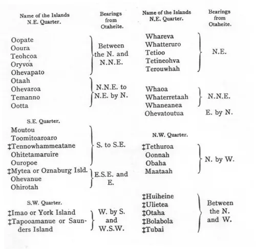
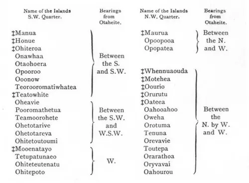
The above list* was taken from a Chart of the Islands drawn by Tupia's own hands. (* This list is hopeless. With the exception of the Society Group (Huiheine, and the names that follow), Imao (Eimeo), Tapooamanuo, Tethuroa, and Ohiteroa, all lying near Tahiti, none can be recognised. Those north and east are no doubt names of the Paumotu Group, low coral islands, disposed in rings round lagoons, whose innumerable names are very little known to this day, and very probably the Tahitians had their own names for them.) He at one time gave us an account of near 130 Islands, but in his Chart he laid down only 74; and this is about the number that some others of the Natives of Otaheite gave us an account of; but the account taken by and from different people differ sencibly one from another both in names and numbers. The first is owing to the want of rightly knowing how to pronounce the names of the Islands after them; but be this as it may, it is very certain that there are these number of Islands, and very Probably a great many more, laying some where in the Great South Sea, the greatest part of which have never been seen by any European.
[Historical Notes on New Zealand.]
NOTES ON NEW ZEALAND.
As already stated by Cook in the Journal, New Zealand was first discovered by Abel Tasman, a Dutch navigator, in the year 1642. Sailing from Tasmania, he sighted the northern part of the Middle island, and anchored a little east of Cape Farewell in Massacre (Golden) Bay, so called by him because the Maoris cut off one of his boats, and killed three of the crew.
Tasman never landed anywhere, but coasted from Massacre Bay along the western side of the North Island to the north point. He passed outside the Three Kings, and thence away into the Pacific, to discover the Friendly Group.
No European eye again sighted New Zealand until Cook circumnavigated and mapped the islands.