Chapters (93)
- Title Page
- Dedication
- Contents
- Map
- The Martain Calendar
- Part 1: Peacock Mountain
- Prologue
- 1
- 2
- Part 2: Areophany
- Prologue
- 1
- 2
- 3
- 4
- Part 3: A New Constitution
- Prologue
- 1
- 2
- 3
- 4
- 5
- 6
- 7
- Part 4: Green Earth
- Prologue
- 1
- 2
- 3
- Part 5: Home at Last
- Prologue
- 1
- 2
- 3
- Part 6: Ann in the Outback
- Prologue
- 1
- 2
- 3
- Part 7: Making Things Work
- Prologue
- 1
- 2
- 3
- 4
- 5
- 6
- Part 8: The Green and the White
- Prologue
- 1
- 2
- 3
- 4
- Part 9: Natural History
- Prologue
- 1
- 2
- Part 10: Werteswandel
- Prologue
- 1
- 2
- 3
- Part 11: Viriditas
- Prologue
- 1
- 2
- 3
- 4
- 5
- 6
- Part 12: It Goes So Fast
- Prologue
- 1
- 2
- 3
- 4
- 5
- Part 13: Experimental Procedures
- Prologue
- 1
- 2
- 3
- 4
- 5
- 6
- 7
- Part 14: Phoenix Lake
- Prologue
- 1
- Acknowledgments
- About the Author
- Bantam Books by Kim Stanley Robinson
- Copyright
The Elysium massif was now a continent in the northern sea. The narrow strait separating it from the southern mainland was a flat stretch of black water and white tabular bergs, punctuated by the stack islands which had been the Aeolis Mensa. The North Sea hydrologists wanted this strait liquid, so that currents could make their way through it from Isidis Bay to Amazonis Bay. To help achieve this liquidity they had placed a nuclear-reactor complex at the west end of the strait, and pumped most of its energy into the water there, creating an artificial polynya where the surface stayed liquid year-round, and a temperate mesoclimate on the slopes on each side of the strait. The reactors’ steam plumes were visible to Nirgal from far up the Great Escarpment, and as he floated down the slope he crossed over thickening forests of fir and ginkgo. There was a cable across the western entrance to the strait, emplaced to snag icebergs floating in on the current. He flew directly over the bergjam west of the cable, and looked down on chunks of ice like floating driftglass. Then over the black open water of the strait— the biggest stretch of open water he had ever seen on Mars. For twenty kilometers he floated over the open water, exclaiming out loud at the sight. Then ahead an immense airy bridge arced over the strait. The black-violet plate of water below it was dotted with sailboats, ferries, long barges, all trailing the white Vs of their wakes. Nirgal floated over them, circling the bridge twice to marvel at the sight— like nothing he had ever seen on Mars before: water, the sea, a whole future world.
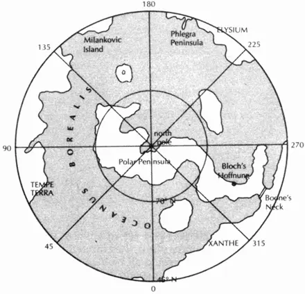
NORTH SEA POLAR PROJECTION
• • •
He continued north, rising over the plains of Cerberus, past the volcano Albor Tholus, a steep ash cone on the side of Elysium Mons. The much bigger Elysium Mons was steep as well, with a Fuji-esque profile that served as the label illustration for many agricultural co-ops in the region. Sprawled over the plain under the volcano were farms, mostly ragged at the edges, often terraced, and usually divided by strips or patches of forest. Young immature orchards dotted the higher parts of the plain, each tree in a pot; closer to the sea were great fields of wheat and corn, cut by windbreaks of olive and eucalyptus. Just ten degrees north of the equator, blessed with rainy mild winters, and then lots of hot sunny days: the people there called it the Mediterranean of Mars.