Chapters (36)
- COVER PAGE
- TITLE PAGE
- COPYRIGHT PAGE
- DEDICATION
- CONTENTS
- PART ONE
- 1. WISEMAN’S FERRY
- 2. WALKING FOR RECONCILIATION
- 3. THE MITCHELL LIBRARY
- 4. CENTENARY OF FEDERATION
- 5. THE SOCIETY OF GENEALOGISTS
- 6. THE PUBLIC RECORD OFFICE
- 7. THREE CRANES WHARF
- 8. LIGHTERMEN
- 9. THE LONDON POOR
- 10. WISEMAN’S LIFE
- 11. VOICES AND PICTURES
- 12. THE GHOST ROOM
- 13. A LITTLE LEARNING
- 14. THE NEWS OF THE DAY
- 15. HISTORIANS
- 16. ABORIGINAL VOICES
- 17. THE BUSH AT NIGHT
- PART TWO
- 18. STARTING TO WRITE
- 19. THE ASSEMBLY
- 20. THE FICTIONAL QUESTER
- 21. THE LAND SPEAKING
- PART THREE
- 22. WHAT HAVE I GOT?
- 23. FINDING THE CHARACTERS
- 24. THE ABORIGINAL CHARACTERS
- 25. DIALOGUE
- 26. THE FIRST READERS
- 27. INTO THE WORLD
- ACKNOWLEDGMENTS
Only a short time later, back in the settlement, the governor’s gamekeeper was speared. No one knew why (or if they did, they weren’t telling). This time Phillip sent a party of soldiers out. The captain in charge, Watkin Tench, left this account of his orders:
His Excellency informed me…that we were to proceed to the peninsula at the head of Botany Bay…and thence… to bring away two natives as prisoners; and to put to death ten; that we were to…cut off and bring in the heads of the slain; for which purpose hatchets and bags would be furnished.
No one died on this occasion but it wasn’t long before the violence started.
Aboriginal people attacked settlers; settlers and soldiers attacked back. Not every day, not every week. But on and off, like a headache.
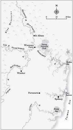
Where these things happened wasn’t always specified, but two places were often mentioned: the Nepean River and the Hawkesbury River. Even though I’d lived in Sydney all my life, I realised I was confused about exactly where they were.
The map showed me why. Sydney is on the seaward edge of a natural basin ringed by mountains. When the first European explorers headed south-west, they came across a river that flowed from south to north along the base of these mountains, and called it the Nepean. Other explorers headed north, and came across a river that flowed from west to east. They called it the Hawkesbury. It took them quite some time to realise that these were the same river. In the north-west corner of the basin, the river did an abrupt right-angle turn.
As it happened, the name of the place on that bend was now Wiseman’s Ferry.
In addition to flowing in two directions and having two names, the river also had two distinct personalities. The part that lay west of Sydney ran through flat ground, a floodplain of fertile alluvial soil. The part that lay north of Sydney had cut down through a vast sandstone plateau, and ran through a cleft between towering cliffs and buttresses, with only small pockets of good land.
Nothing grew around Sydney itself. (It still doesn’t. That was why Mum needed all that cow manure.) The first good farms were on the river west of the township, on those fertile river-flats. Settlers cleared, fenced and planted. Pretty soon the farms were everywhere along the river.
It was these small farms—isolated and vulnerable—that were usually attacked. Soldiers were stationed in the area, but at harvest time the Aboriginal people swooped in, set fire to field after field of ripe grain, and were gone before the soldiers could get there. Settlers were speared, Aboriginal people were shot.
When roads were primitive, wagons slow, and the bush full of robbers, rivers made the best highways.